January 19, 2016
By Florida Sportsman
By Corky Decker
Find blue water and save big using sea surface temp services.
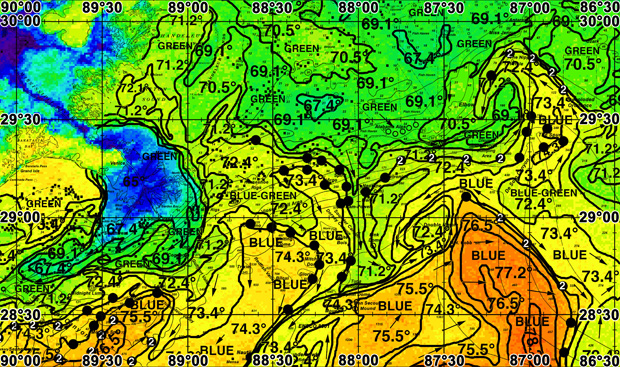
 "Black dots" ROFFs analysis for northern Gulf reveals hotspots where cooler, green water transitions into warm blue water.\
The Gulf of Mexico is a hard place to fish offshore. You have to travel upwards of a hundred miles to get to 100 fathoms, if you live in the Big Bend or south towards the Tampa area. The Panhandle, you are a lot closer to the deep water, but also a lot closer to that huge muddy river to the west.
The Mississippi River dumps billions of gallons into the Gulf of Mexico every day. Offshore currents and winds can send the river water hundreds of miles from the Louisiana source and dirty up our prime marlin spots off Destin and Pensacola. There is nothing I hate more than burning daylight hours and worse, three- to four-dollar-a-gallon fuel in green water. I have never caught a billfish in the green water. I burn more fuel because I'm mad, and keep bumping the throttles up. It is hard to pull a marlin spread at 15 knots. I need the blue water.
I'm not a rich man but I have a rich man's habit, so I save money and billfish on the cheap (well, kinda). Fuel is where you can save. How do I save enough money on my fuel bill to be able to follow my passion? I go 8 knots everywhere, and I order a ROFFS Fishing Oceanographic Analysis before we leave the dock. Marlin fishing for me out of the Panhandle is a 4 p.m. departure, an 8-knot overnight trip to the Spur or where Dr. Roffer told me the blue water can be found. I wake up at daybreak in the blue water, and put out a spread. I'm fishing before the guy with the 40-knot G&S arrives. He burned 500 gallons getting to where I am. I burned 40 gallons, slept 6 hours and am in the tower with a cup of coffee.
I knew where I was going before I left the dock. I saved search time. I hate search time. It costs me money and lines-in time. I fished throughout South Pacific for seven years. I'm spoiled, really spoiled (and also why I can't afford my G&S). I also learned from my time doing 10-day liveaboard charters with a 40-foot boat and fuel bladders: You went 8 knots and always pulled lures when you traveled. You fished. We caught hundreds of blue marlin, and we burned an average of 50 gallons a day and anchored up at night, shutting the genset down when we all went to sleep.
I took this lesson with me to the Gulf. I go easy on the fuel, drift for swords at night, and we leave the genset going (I like my AC; I'm in my fifties now).
There are other available satellite services. Some of my buddies use Hiltons. FishTrack is another site which has come along in the last year or two. I can only write about what I know and those are the ROFFS. Never used anything else. Those guys have Ph.Ds in fish science. Your 60 bucks gets you an interpretation of realtime ocean information for fishing. They even put big black dots with numbers inside where you should look. Great waypoint, start there! The higher the number, the greater the chances for finding fish. Some free sites, such as one hosted by Rutgers University,
offer pretty satellite images, but lack the interpretation and analysis.
The Gulf of Mexico is the hardest body of water I have ever fished for marlin, but jeez it can be really good! Our best day is one blue and four whites. That is not Vanuatu or Cape Verde numbers, but tagging 5 billfish a day is still a day. I had that day on one of those little black dots. FS
First published Florida Sportsman Magazine August 2015
